
Rail Baltica Uses GIS to Collect and Deliver Construction Data via a Single Platform
Rail Baltica is digitising a railway from the ground up, and the data it collects today will serve the infrastructure managers of tomorrow.
www.esri.com
© Esri
The scale and complexity of the Rail Baltica greenfield infrastructure project is vast. When complete, the railway line will link Estonia, Latvia and Lithuania with the broader European rail network via 870km of track. Beyond track and switches, the project also encompasses electrical and water networks, 5G and broadband communications, signalling systems, terminals and stations.
A project of this scope involves hundreds of contractors and generates large amounts of data every day. In many cases, this information is stored in different locations by teams working independently, and there are limited shared guidelines for how it should be collected or exchanged. As a result, it can be difficult to know what’s already been gathered, which sometimes leads to unintentional duplication – for example, multiple teams photographing the same objects without realizing the material already exists.
Vaidas Ulenskas, GIS Team Leader at Rail Baltica, said:
"There's no order."
Creating a Single Source of Information
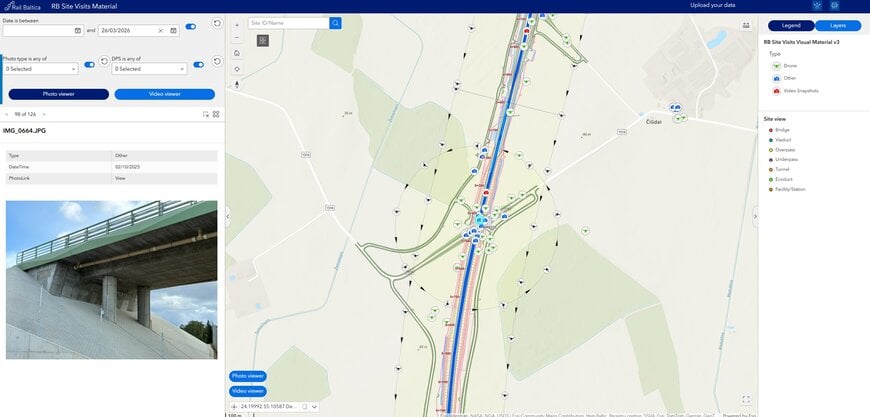
For Rail Baltica, the solution is to create a single, structured platform that brings everything together. This is a geospatial digital twin, built on an Esri GIS that provides a virtual representation of the railway’s entire planned and operational infrastructure.
Vaidas Ulenskas, GIS Team Leader at Rail Baltica, said:
"When there are different departments with their own ways of understanding and collecting data, someone has to put everything in one place and make it make sense for everyone. That's what we do. GIS forces us to create clear workflows: how data should be collected, where it should be stored and how to make sure it's accessible to everyone."
Jovita Starynina, Head of Virtual Design and Construction at Rail Baltica, said:
"We receive a huge amount of data. To have it all in one platform, understandable to everyone, with a view of the full project across three countries — that's very rare for a megaproject."
A Smarter Way to Monitor
The team needed a way to monitor everything efficiently, and while photos, drone footage, aircraft imagery and satellite data were all considered, it was photo and video that quickly stood out.
Vaidas Ulenskas said:
"Everyone knows what photos are. Everyone knows how to use video. And at the same time, modern technologies like GIS allow you to extract much more value from these simple formats and reuse them in different ways. It's cost-efficient, easy to collect and everyone understands how it works."
The result is a cultural shift as much as a technical one. Colleagues can check construction progress from their desks without travelling to site, and teams are using the platform to track how specific locations have changed as construction progressed.
Bringing that data together also revealed something unexpected.
Vaidas Ulenskas said:
"One of the best things is that people have started discovering there's available material that they didn't know existed. I really like that we're now making the most of everything we have."
The Defect that Video Caught First
The value of a GIS approach has already been demonstrated in a telling real-world example. Weekly videos showed that barriers had been installed in the wrong position on a construction section back in January 2025, however the issue wasn’t formally identified until LiDAR scanning six months later.
Vaidas Ulenskas noted:
"It shows that simpler data formats move faster through the project and can help us spot issues earlier. Construction videos are recorded weekly and reach relevant users within days. LiDAR scanning only happens after specific construction stages and by the time the data is collected, processed and transferred, months can have passed. This is important because the earlier a defect is caught, the cheaper it often is to fix."
This example also reveals a second, equally important lesson. While the footage had been available every week, the issue went unnoticed until someone happened to spot it on site.
Vaidas Ulenskas noted:
"Collecting data isn't enough. We learnt we must ensure that the right people are actually reviewing it".
Leave No Data Behind
Underpinning the use of GIS is what Ulenskas calls ‘digital sustainability’ — a principle he considers as important as ‘physical’ sustainability, but far less talked about. The idea comes from a moment he witnessed from his office window, where he saw a worker climb into a drainage pipe, take photos and climb out, only for the site manager to then transfer the information gathered onto paper.
Vaidas Ulenskas said:
"I witnessed the digital data become irrelevant straight away, while knowing that paper would likely end up in the bin after a few days. In that moment I realised how much digital data can be lost during projects and wanted to ensure that once data was collected, it's never wasted."
Today, data collection on Rail Baltica runs on two tracks. The first is scheduled contractor submissions: weekly videos and images captured to a defined specification. The second, which Ulenskas considers potentially more valuable, is data collected by Rail Baltica’s own specialists during site visits.
Vaidas Ulenskas said:
"When our colleagues go on site, they know exactly what they're looking for. A bridge expert will focus on bridges, a hydrology expert on something else entirely. That focused data is extremely valuable."
Training programmes are underway to improve metadata capture, and engagement is growing.
Vaidas Ulenskas said:
"People are asking how to improve things. That tells us they're using the system, and that's exactly what we want to see."
An Asset Register Built to Last
As the project progresses, GIS is being used in different ways. In the design phase, it was primarily used for corridor planning, environmental analysis and data collection. Now, with construction underway on multiple sites, it’s become the operational backbone of progress monitoring, and the foundation of an asset register that runs as a continuous thread from design through to future operations and maintenance.
Jovita Starynina said:
"All the data we collected during design can now be reused in construction, checking what was designed against what's being built. When something's missing or there's a mismatch, the asset register lets us check object by object. We may not have eliminated all data loss between phases, but we've significantly reduced it. When data is in GIS, it can't be lost, it's there forever."
Jovita Starynina continued:
"We're collecting and creating data with the future in mind. That's always been the intention."
As a greenfield project that’s been digitising from day one, Rail Baltica has a significant advantage over legacy railways, many of which face costly programmes to now digitise decades of physical records. The beneficiaries will ultimately be the infrastructure managers who take over when the railway opens.
Jovita Starynina said:
"We're collecting as much as we can so in future, they'll be able to access whatever information they need."
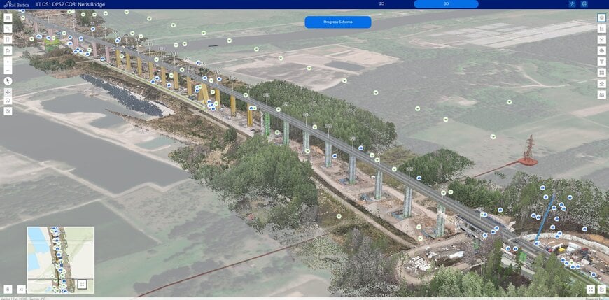
Railway viaduct supervision
© Esri
The Benefits and the Bigger Picture
Vaidas Ulenskas said:
"The biggest savings are in time. Data is available to everyone, which helps decision makers act faster. We've reduced the time it takes to access, collect and share data, and that compounds across a project of this scale."
Jovita Starynina said:
"Data is an asset in its own right. That simply wouldn't be possible without GIS."
Ulenskas, meanwhile, sees this work as something larger than a single infrastructure project. When he joined the company only a handful of people knew what GIS was. Today, contractors come to his team asking about it specifically.
Vaidas Ulenskas said:
"My secret mission is to use this project as a platform to show the wider construction and transport industry what GIS can do. Lead by example. That's the idea."
With AI-assisted change detection on the horizon and a fully digitised asset base already in place, Rail Baltica is well positioned to do just that.
www.esri.com